
Rob-n-Hild, oot and aboot eh? Sorry - 2022
|
Click links to jump to specific days: Start | Nerdy | The Largest... | Ornaments
|
|||||||||||||||||||||||||||||||||||||||||||||||||||||||||||||||
|
Cache Creek - Kamloops and around (257 km. 4 hrs. Max elevation 1353) 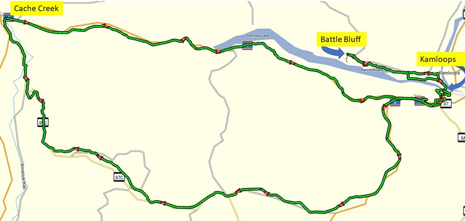
|
|||||||||||||||||||||||||||||||||||||||||||||||||||||||||||||||
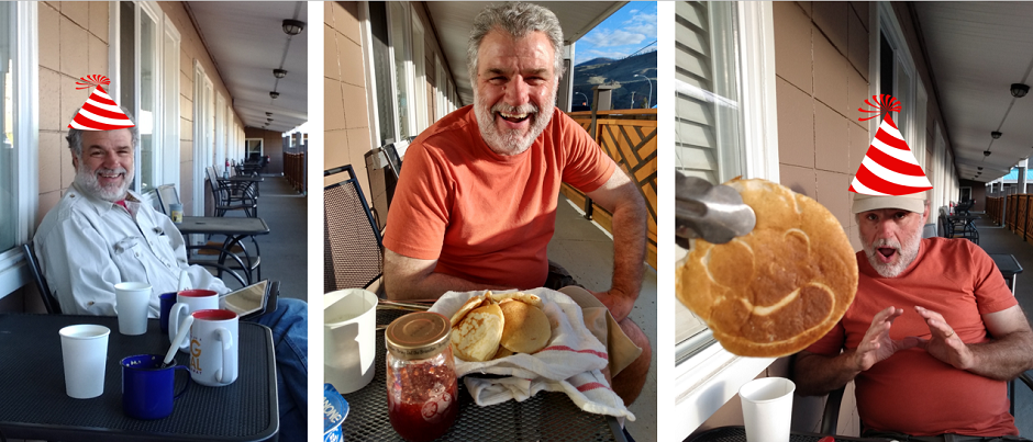
| We started off celebrating Rob's birthday with porridge, milk, and tea on our porch. And then we finished it off celebrating more with birthday pancakes - including a "giant" pancake with a face on it. Tee-hee. | |||||||||||||||||||||||||||||||||||||||||||||||||||||||||||||||
|
|||||||||||||||||||||||||||||||||||||||||||||||||||||||||||||||
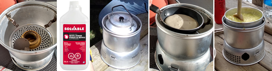
| Yesterday we fielded a question from Australia. Today we reply to a question from Mexico: How do you manage to have hot tea everywhere? Battery operated kettle?. The answer it the best camping stove ever: Trangia brand. It runs on methylated spirits and is super efficient. After 3 weeks we are still on our first litre of fuel, which we have found we can buy at Canadian Tire (paint section). Most frequently we make tea, we boil water for porridge and hot chocolate, we make pancakes, and Rice-a-Roni. Quick and easy. | |||||||||||||||||||||||||||||||||||||||||||||||||||||||||||||||
|
|||||||||||||||||||||||||||||||||||||||||||||||||||||||||||||||
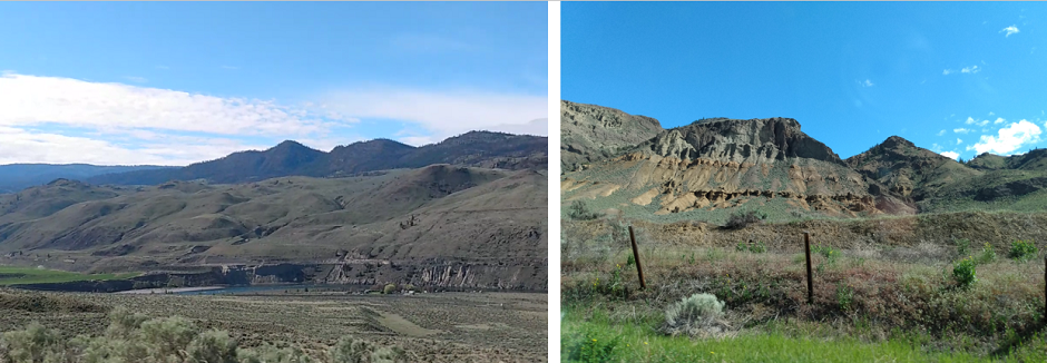
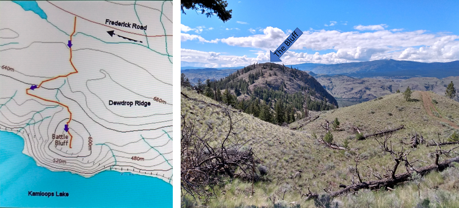
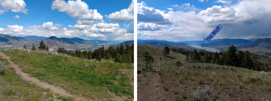
| Before we got as far as evening pancakes, we headed from Cache Creek to Kamloops. The goal was to hike out onto Battle Bluff west out of Kamloops on the north side of Thompson River. The drive over was beautiful with amazing landscape. | |||||||||||||||||||||||||||||||||||||||||||||||||||||||||||||||
|
|||||||||||||||||||||||||||||||||||||||||||||||||||||||||||||||
| We were the third car to park at the trail head. The road in there was quite windy and a rough dirt track towards the end. We figured we might be alone, but by the time we got back from our walk, recent arrivals were having to park at the overflow car park. A popular 5 km return hike! | |||||||||||||||||||||||||||||||||||||||||||||||||||||||||||||||
|
|||||||||||||||||||||||||||||||||||||||||||||||||||||||||||||||
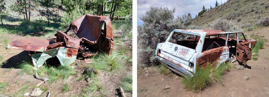
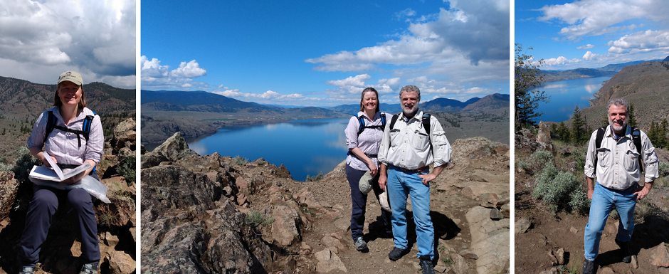
| For part of the way we shared the experience with a local family with three generations ranging from 5 years to 70+ years. We admired the view - including oddly two stripped down and rusted old cars. We have no idea how they got here. | |||||||||||||||||||||||||||||||||||||||||||||||||||||||||||||||
|
|||||||||||||||||||||||||||||||||||||||||||||||||||||||||||||||
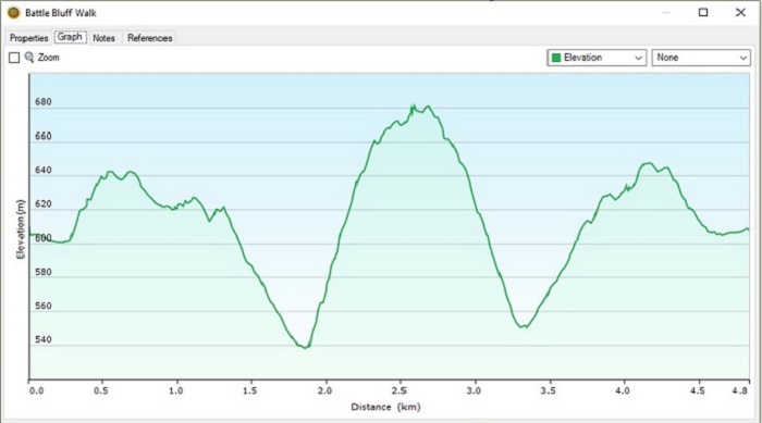
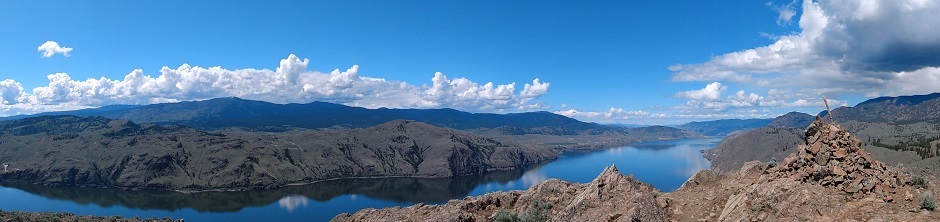
| The hike was quite exhausting with lots of up and down. First dropping down 600 to 540 and then climb up again to 680 metres. The good part was that we got to say hello to several doggies and chat with their parents. And then at the end of it all, the view was fantastic. | |||||||||||||||||||||||||||||||||||||||||||||||||||||||||||||||
|
|||||||||||||||||||||||||||||||||||||||||||||||||||||||||||||||
| A local hiker pointed out that there is a book to sign hidden on the cairn at the top. The cairn was built in 1987 to remember a local gentleman who died suddenly, and his wife died some years later. Since then visitors have been signing the book and adding stories. We added our bit too. It was very rewarding to know that we can do a decent hike still, particularly Rob who is so old now! Tee-hee. | |||||||||||||||||||||||||||||||||||||||||||||||||||||||||||||||
|
|||||||||||||||||||||||||||||||||||||||||||||||||||||||||||||||
| Next we needed a break so we went downtown Kamloops and had Mexican food (burrito and quesadilla), a quick stop at Shoppers Drug Mart to look for chocolate covered jujubes because our emergency ration is running very low. No luck in this one so we keep looking whenever we see a Shoppers. It was also time to fill up with gas so off to Costco we went. The line was amazingly short for a Saturday. Next we were off to do another hike - this time in the area around Mount Dufferin. | |||||||||||||||||||||||||||||||||||||||||||||||||||||||||||||||
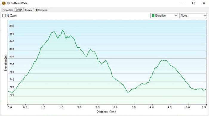
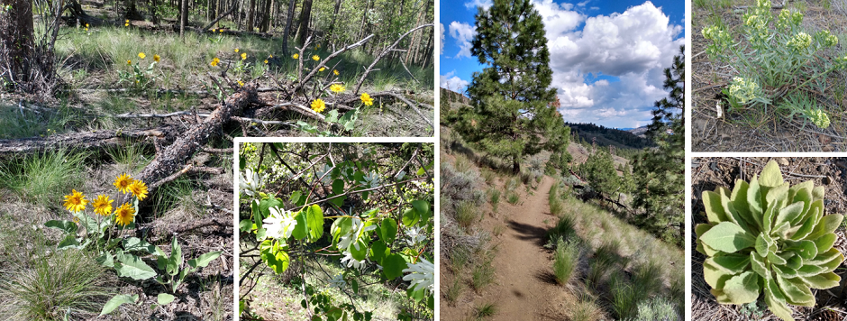
| We parked at the Copperhead trailhead and set off up the hill. And what a hill it was ascending from 710 to 870 metres. We have a certain skill where we aim to have a short urban walk and then suddenly we are hiking straight up onto the highest mountain, huffing and puffing. Several nice flowers/plants and excellent views again, though. We could see all the way across the valley to the Bluff where we huffed and puffed a few hours earlier. | |||||||||||||||||||||||||||||||||||||||||||||||||||||||||||||||
|
|||||||||||||||||||||||||||||||||||||||||||||||||||||||||||||||
| For our return home, we decided to drive south along the famous Coquihalla Highway. At least it is famous among our friends because we have had many recommendations to drive it. We'll continue south on it tomorrow on our way to Vancouver. Tonight we turned west and took route 97D and C back to Cache Creek. This is where we hit those high elevations above 1,300. So of course we were driving in sleet. Not enough to make us worry about the road conditions, but enough to make us video it! | |||||||||||||||||||||||||||||||||||||||||||||||||||||||||||||||
| Click to view MP4 video file of sleet | |||||||||||||||||||||||||||||||||||||||||||||||||||||||||||||||
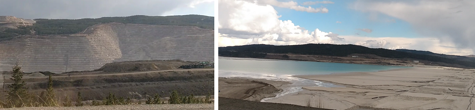
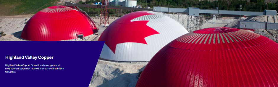
| Driving through Logan Lake we saw a typical rural town supporting mining industry, and not long after we passed a huge copper mine (Highland Valley Copper). Very photogenic it was too! | |||||||||||||||||||||||||||||||||||||||||||||||||||||||||||||||
|
|||||||||||||||||||||||||||||||||||||||||||||||||||||||||||||||
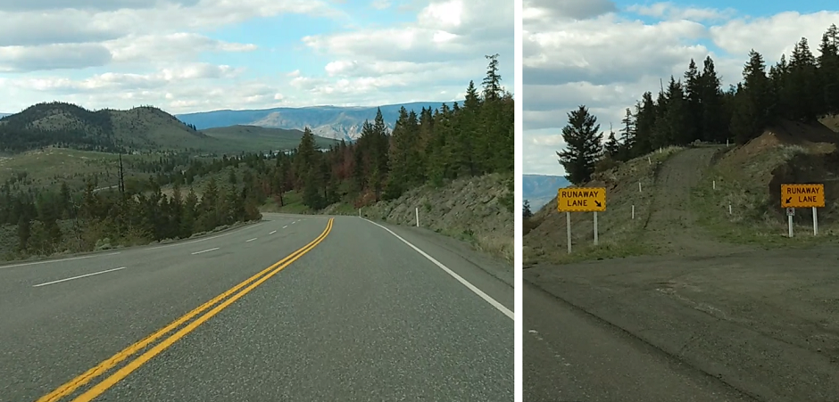
| After the mine we started descending and descending. We travelled from 1260 to 460 metres elevation in 10 km! There were multiple runaway lanes so trucks who had lost their brakes could stop safely - or at least quickly without running off the road and into cars. | |||||||||||||||||||||||||||||||||||||||||||||||||||||||||||||||
|
|||||||||||||||||||||||||||||||||||||||||||||||||||||||||||||||
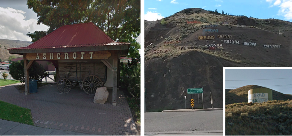
| The last town we drove through before returning back at Cache Creek was Ashcroft. We didn't spend time there to explore, but we saw their old cart and welcome sign plus a junction where it seems all the graduating classes post their sign. Presumably this is an alternative to painting their year on the side of water tanks. | |||||||||||||||||||||||||||||||||||||||||||||||||||||||||||||||
|
|||||||||||||||||||||||||||||||||||||||||||||||||||||||||||||||
| We got back to our motel bought some milk and made birthday pancakes for Rob. The sunset was beautiful over our motel. A great end to another fun day. | |||||||||||||||||||||||||||||||||||||||||||||||||||||||||||||||
|
Coming up: Off to Vancouver via the Coquihalla Highway. | Start | Nerdy | The Largest... | Ornaments | Go To Previous Day | Go To Next Day |
|||||||||||||||||||||||||||||||||||||||||||||||||||||||||||||||
May/June 2022